AD 2 MILITARY AERODROMES
EBBE — BEAUVECHAIN (MIL)
EBBE AD 2.1 Aerodrome Location Indicator and Name
EBBE — BEAUVECHAIN (MIL)
EBBE AD 2.2 Aerodrome Geographical and Administrative Data
| 1 | ARP coordinates | 504528N 0044601E |
| Site of ARP at aerodrome | ||
| 2 | Direction and distance from (city) | 3 NM S of Beauvechain |
| 3 | Elevation / reference temperature | 362 FT / 23.1°C |
| 4 | Geoid undulation at AD ELEV PSN | 150 FT |
| 5 | Magnetic variation / annual change | 2°E (2022) / INFO not AVBL |
| 6 | Name of AD operator | Belgian Air Component |
| Address | 1W Base Lt Col Avi Ch. Roman 1320 Beauvechain BELGIUM | |
| TEL | + 32 (0) 2 442 55 00 (ATC SUP) + 32 (0) 2 442 59 14 (Wing OPS) | |
| FAX | NIL | |
| NIL | ||
| AFS | EBBEZPZX | |
| Website | Not applicable | |
| 7 | Types of traffic permitted (IFR/VFR) | IFR / VFR |
| 8 | Remarks | A concession for flying activity outside military OPS HR has been given to CIV clubs.See EBBE AD 2.23 for more information. |
EBBE AD 2.3 Operational Hours
| 1 | AD Operator | The following schedule applies (HOL excl)(1):
|
| 2 | Customs and immigration | HS / HX |
| 3 | Health and sanitation | HS |
| 4 | AIS Briefing Office | As AD Operator |
| 5 | ATS Reporting Office (ARO) | NIL |
| 6 | MET Briefing Office | As AD Operator |
| 7 | ATS | As AD Operator |
| 8 | Fuelling | Outside 0730-1630 (0630-1530), non home base aircraft need 10 days prior request |
| 9 | Handling | As AD Operator |
| 10 | Security | As AD Operator |
| 11 | De-icing | Not AVBL |
| 12 | Remarks | (1) Planned opening of aerodrome outside HO will be announced by NOTAM. Aerodrome may be activated by COMOPSAIR outside normal hours of operation without previous notice. Activity must always be checked via Steenokkerzeel ATCC or Brussels FIC. |
EBBE AD 2.4 Handling Services and Facilities
| 1 | Cargo-handling facilities | AVBL (no linked pallets) |
| 2 | Fuel types | F-18, F-34 (1)(2) |
| Oil types | O-148, O-156, H-515 (1)(2)(3) | |
| 3 | Fuelling facilities and capacity | No limitations (single point and gravity) |
| 4 | De-icing facilities | Not AVBL |
| 5 | Oxygen | LHOX, LOX (1)(4) |
| 6 | Starting units | 3 x PDF 124 3 x 28 VDC/2000 A 3 x 115 VAC/400 HZ Compressed air, compressor unit 50 psi |
| 7 | Hangar space for visiting aircraft | Two Hardened Aircraft Shelters (HAS) Limitations:
|
| 8 | Repair facilities for visiting aircraft | SF 260 |
| 9 | Remarks | (1) See AD 1.1, § 2.2 (2) ‘SOAP’ AVBL till 1436 (3) Actual availability to be checked with Wing OPS (4) Nitrogen (high and low pressure) AVBL |
EBBE AD 2.5 Passenger Facilities
| 1 | Hotels | Limited overnight accommodations on the AD |
| 2 | Restaurants | Mess |
| 3 | Transportation | AVBL |
| 4 | Medical facilities | Medical officer, first aid - ambulance(s) |
| 5 | Bank | |
| Post office | ||
| 6 | Tourist office | |
| 7 | Remarks | NIL |
EBBE AD 2.6 Rescue and Fire Fighting Services
| 1 | Aerodrome category for fire fighting | STANAG 3712 - CAT 8(1) |
| 2 | Rescue equipment | STANAG 3712 - CAT 8 compliant |
| 3 | Capability for removal of disabled aircraft | Not applicable for crash fire rescue services |
| 4 | Remarks | (1) See AD 1.2 |
EBBE AD 2.7 Runway Surface Condition Assessment and Reporting, and Snow Plan
| 1 | Types of clearing equipment |
|
| 2 | Clearance priorities |
|
| 3 | Remarks | NIL |
EBBE AD 2.8 Aprons, Taxiways and Check Locations/Positions Data
| 1 | Apron designation, surface and strength | Apron C3, C7, H2, H5, H11: CONC, INFO not AVBL |
| 2 | Taxiway designation, width, surface and strength | TWY S4: 9 M, INFO not AVBL, LCN 30 All other TWY: 12 M, INFO not AVBL, LCN 30 |
| 3 | ACL and elevation | C3: 384 FT (1) C7: 375 FT (1) H2 parking K: 333 FT (1) H2 parking L: 333 FT (1) H5: 334 FT (1) H11 parking I: 328 FT (1) H11 parking J: 326 FT (1) |
| 4 | VOR check points | |
| 5 | INS check points | C3: 504437N 0044558E (1) C7: 504443N 0044610E (1) H2 parking K: 504539N 0044539E (1) H2 parking L: 504535N 0044535E (1) H5: 504540N 0044552E (1) H11 parking I: 504552N 0044630E (1) H11 parking J: 504558N 0044558E (1) ORP 22: 504556N 0044644E (1) ORP 04: 504453N 0044527E (1) |
| 6 | Remarks | NIL |
EBBE AD 2.9 Surface Movement Guidance and Control System and Markings
| 1 | Aircraft stand identification signs | NIL |
| Taxiway guide lines | NIL | |
| Visual docking/parking guidance system at aircraft stands | NIL | |
| 2 | Runway markings and lighting | Designation, threshold, centre line |
| Taxiway markings and lighting | Centre line, holding positions | |
| 3 | Distance markers | Every 1 000 FT signalling remaining RWY distance (illuminated on primary RWY 04L/22R) |
| Runway guard lights | NIL | |
| 4 | Other runway protection measures | NIL |
| 5 | Stop bars | NIL |
| 6 | Other | Indicating panels and follow-me car |
| 7 | Remarks | NIL |
EBBE AD 2.10 Aerodrome Obstacles
1 SPECIFIC OBSTACLES
- To avoid pilots from coming in too low on RWY 04L, the portion of RWY in front of the threshold markings of RWY 04L is marked with yellow chevrons, thus indicating clearly to pilots not to touch before over the threshold markings. The portion marked with these yellow chevrons is nevertheless usable for ground movements of aircraft;
- Runway observer shelter 15 FT high, 50 M south of centreline abeam VFR THR 04R and VFR THR 22L.
2 OTHER OBSTACLES
No Area 2 or Area 3 obstacle data sets are currently provided for EBBE.
Details on EBBE aerodrome obstacles can be found on the aerodrome obstacle charts (see EBBE AD 2.24).
EBBE AD 2.11 Meteorological Information Provided
| 1 | Associated MET Office | EBBE MET |
| 2 | Hours of service | As AD OPR HR |
| MET Office outside hours | ||
| 3 | Office responsible for TAF preparation | EBBE MET 12 HR |
| Periods of validity | 9 HR | |
| 4 | Type of landing forecast | Colour state |
| Interval of issuance | 2 HR or more often when necessary | |
| 5 | Briefing / consultation provided | TEL, personal consultation, MOSA computer system |
| 6 | Flight documentation | Charts, abbreviated plain language text |
| Languages used | En | |
| 7 | Charts and other information available for briefing or consultation | Surface charts, altitude charts, prognostic altitude charts, prognostic chart of significant weather, tropopause and maximum wind chart |
| 8 | Supplementary equipment available for providing information | Weather radar, receiver of cloud photographies transmitted by satellite, FAX and self-briefing terminal |
| 9 | ATS units provided with information | TWR, APP and AIS (O/R) |
| 10 | Additional information | NIL |
EBBE AD 2.12 Runway Physical Characteristics
| RWY designator | True BRG | Dimensions of RWY (m) | Strength (PCN) and surface of RWY and SWY | THR COORD | THR ELEV and highest ELEV of TDZ of precision APCH RWY |
|---|---|---|---|---|---|
| RWY end COORD | |||||
| THR geoid undulation | |||||
| 1 | 2 | 3 | 4 | 5 | 6 |
| 04L | 039° | 3079 x 45 | PCN 93 F/C/W/T ASPH / CONC | 504457.76N 0044523.17E | THR 349 FT TDZ 350 FT |
| 504606.52N 0044650.32E | |||||
| 150 FT | |||||
| 22R | 219° | 3079 x 45 | PCN 93 F/C/W/T ASPH / CONC | 504557.75N 0044639.27E | THR 315 FT TDZ 331 FT |
| 504448.87N 0044511.81E | |||||
| 150 FT | |||||
| 04R | 039° | 2436 x 22.5 | PCN 24 F/B/W/T ASPH / CONC | 504449.54N 0044536.63E | THR 362 FT TDZ 362 FT |
| 504549.41N 0044652.45E | |||||
| 150 FT | |||||
| 22L | 219° | 2436 x 22.5 | PCN 24 F/B/W/T ASPH / CONC | 504547.94N 0044650.66E | THR 316 FT TDZ 333 FT |
| 504447.99N 0044534.58E | |||||
| 150 FT |
| RWY designator | Slope of RWY and SWY | SWY dimensions (M) | CWY dimensions (M) | Strip dimensions (M) | Dimensions of RESA |
|---|---|---|---|---|---|
| 7 | 8 | 9 | 10 | 11 | 12 |
| 04L | Long: 1.2 % Trans: 1.0 % | 277 | 302 | NIL | |
| 22R | Long: 1.2 % Trans: 1.0 % | 259 | 294 | NIL | |
| 04R | NIL | NIL | NIL | NIL | |
| 22L | NIL | NIL | NIL | NIL |
| RWY designator | Location and description of arresting system | OFZ | RMK |
|---|---|---|---|
| 13 | 14 | 15 | 16 |
| 04L | See below | NIL | NIL |
| 22R | See below | NIL | NIL |
| 04R | See below | NIL | NIL |
| 22L | See below | NIL | NIL |
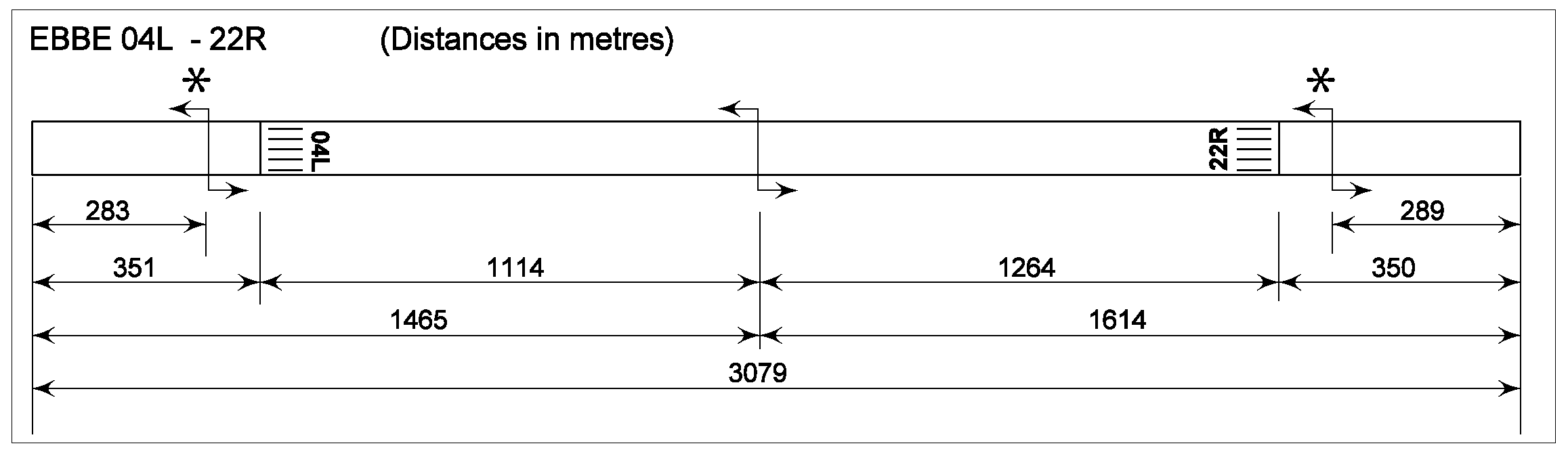
| 1 | Type | Cable for bi-directional engagement with tailhook. |
| 2 | Nomenclature | AERAZUR 4M6-C |
| 3 | Energy-absorbing capacity | 180 MJ / 135 x 106 FT x lb |
| 4 | Nominal stop distance | 285 M (935 FT) |
| 5 | Hook-load | 50 000 lbs (160 kn - 33 000 lbs) |
| 6 | Cable diameter | 1” |
| 7 | Location on RWY | Indicated on the diagram below with an asterix (*) |
| 8 | Remarks | NIL |
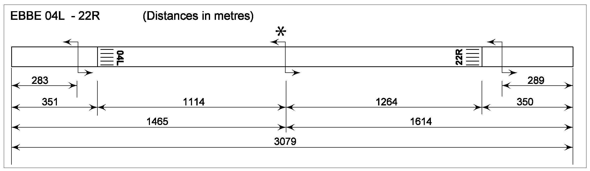
| 1 | Type | Retractable cable for bi-directional engagement with tailhook. |
| 2 | Nomenclature | 500 S6 / BAK - 14 |
| 3 | Energy-absorbing capacity | 67.3 x 10⁶ FT x lb x 2 |
| 4 | Nominal stop distance | 290 M (950 FT) |
| 5 | Hook-load | 30 000 lbs |
| 6 | Cable diameter | 1” |
| 7 | Location on RWY | Indicated on the diagram below with an asterix (*) |
| 8 | Remarks | NIL |
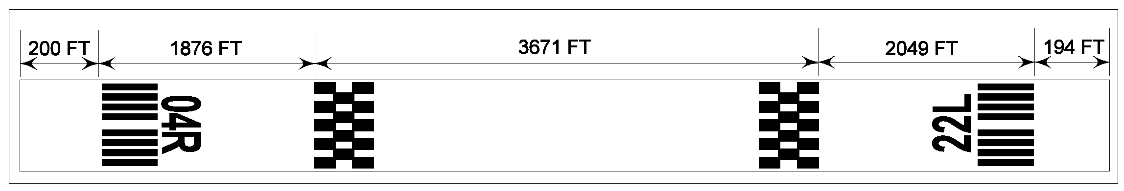
Note: On the secondary RWY (04R/22L) a portable ACFT arresting system (PORTARREST) for tailhook equipped ACFT can be installed for planned OPS.
EBBE AD 2.13 Declared Distances
| RWY designator | TORA (M) | TODA (M) | ASDA (M) | LDA (M) | RMK |
|---|---|---|---|---|---|
| 1 | 2 | 3 | 4 | 5 | 6 |
| 04L | 2742 | 3044 | 3019 | 2426 | NIL |
| 22R | 2760 | 3054 | 3019 | 2435 | NIL |
| 04R | 2436 | 2436 | 2436 | 2375 | NIL |
| 22L | 2436 | 2436 | 2436 | 2376 | NIL |
The RWY 04R/22L is mainly used for SF 260 ACFT operations of the 1 W. It may be used as auxiliary RWY for tactical ACFT for operational reasons when arresting system is installed.
The VFR operations of light ACFT on the RWY 04R/22L are limited to a portion of this RWY only. This portion is indicated by a VFR threshold, which is painted in a distinct design of checkers.
EBBE AD 2.14 Approach and Runway Lighting
| RWY 04L | ||||||
|---|---|---|---|---|---|---|
| Approach lighting system | Type: | ALS with sequenced flashing lights | VASIS | Type: | PAPI (both sides / 3°) | |
| Length: | 930 M | MEHT: | ||||
| Intensity: | LIH | |||||
| Runway threshold lights | Colour: | green | Touchdown zone lights | NIL | ||
| Wing bars: | NIL | |||||
| Runway end lights | Colour: | red | Stopway lights | |||
| Wing bars: | NIL | |||||
| Runway centre line lights | Length: | |||||
| Spacing: | ||||||
| Intensity: | ||||||
| Runway edge lights | Length: | |||||
| Spacing: | 60 M | |||||
| Intensity: | LIH directional & omnidirectional | |||||
| Remarks | NIL | |||||
| RWY 22R | ||||||
|---|---|---|---|---|---|---|
| Approach lighting system | Type: | ALS with sequenced flashing lights | VASIS | Type: | PAPI (both sides / 3°) | |
| Length: | 930 M | MEHT: | ||||
| Intensity: | LIH | |||||
| Runway threshold lights | Colour: | green | Touchdown zone lights | NIL | ||
| Wing bars: | NIL | |||||
| Runway end lights | Colour: | red | Stopway lights | |||
| Wing bars: | NIL | |||||
| Runway centre line lights | Length: | |||||
| Spacing: | ||||||
| Intensity: | ||||||
| Runway edge lights | Length: | |||||
| Spacing: | 60 M | |||||
| Intensity: | LIH directional & omnidirectional | |||||
| Remarks | NIL | |||||
| RWY 04R | ||||||
|---|---|---|---|---|---|---|
| Approach lighting system | Type: | Non-standard | VASIS | Type: | PAPI (left / 3°) | |
| Length: | 260 M | MEHT: | ||||
| Intensity: | ||||||
| Runway threshold lights | Colour: | Touchdown zone lights | ||||
| Wing bars: | ||||||
| Runway end lights | Colour: | Stopway lights | ||||
| Wing bars: | ||||||
| Runway centre line lights | Length: | |||||
| Spacing: | ||||||
| Intensity: | ||||||
| Runway edge lights | Length: | |||||
| Spacing: | ||||||
| Intensity: | LIH omnidirectional | |||||
| Remarks | NIL | |||||
| RWY 22L | ||||||
|---|---|---|---|---|---|---|
| Approach lighting system | Type: | Non-standard | VASIS | Type: | PAPI (left / 3°) | |
| Length: | 260 M | MEHT: | ||||
| Intensity: | ||||||
| Runway threshold lights | Colour: | Touchdown zone lights | ||||
| Wing bars: | ||||||
| Runway end lights | Colour: | Stopway lights | ||||
| Wing bars: | ||||||
| Runway centre line lights | Length: | |||||
| Spacing: | ||||||
| Intensity: | ||||||
| Runway edge lights | Length: | |||||
| Spacing: | ||||||
| Intensity: | LIH omnidirectional | |||||
| Remarks | NIL | |||||
EBBE AD 2.15 Other Lighting and Secondary Power Supply
| 1 | ABN / IBN location, characteristics and hours of operation | |
| 2 | LDI location and lighting | |
| WDI location and lighting | ||
| 3 | Taxiway edge lighting | Omnidirectional lighting, except TWY S4 no lighting |
| Taxiway centre line lighting | ||
| 4 | Secondary power supply | NIL |
| Switch-over time | ||
| 5 | Remarks | NIL |
EBBE AD 2.16 Helicopter Landing Area
| 1 | Coordinates TLOF or THR of FATO | 504457.3N 0044615.6E APRX 900 M NE of TWR, see AD 2.24 ADC.01 or AD 2.24 GMC.01 or BEMIL FLIP VFR and IFR |
| Geoid undulation | INFO not AVBL | |
| 2 | TLOF and/or FATO elevation | 110 M/361 FT |
| 3 | TLOF and FATO area dimensions | 45 M x 30 M |
| Surface | CONC | |
| Strength | INFO not AVBL | |
| Marking | Standard helipad markings | |
| 4 | True BRG of FATO | NIL |
| 5 | Declared distance available | NIL |
| 6 | APCH and FATO lighting | No |
| 7 | Remarks | NIL |
EBBE AD 2.17 ATS Airspace
| 1 | Designation | Beauvechain CTR (1) |
| Lateral limits | 504151N 0043016E - 505718N 0045201E - 505356N 0050240E - an arc of circle, 7.7 NM radius, centred at 504654N 0045728E and traced clockwise to 504836N 0050925E - 504157N 0045525E - 503941N 0044955E - 503502N 0044248E - an arc of circle, 10.6 NM radius, centred at 504528N 0044601E and traced clockwise to 504151N 0043016E. | |
| 2 | Vertical limits | 2 500 FT AMSL |
| 3 | Airspace classification | D |
| 4 | ATS unit call sign | Beauvechain Tower (2) |
| Language(s) | En | |
| 5 | Transition altitude | 4 500 FT AMSL |
| 6 | Hours of activation | As ATS operational hours. See AD-2.3 |
| 7 | Remarks | (1) Outside EBBE OPR HR, airspace is not active. As EBBE may be re-activated at any time, civil pilots are advised to avoid crossing whenever possible. Activation can be checked with Steenokkerzeel ATCC or Brussels FIC. |
| (2) For crossing clearance only, contact Beauvechain APP. |
EBBE AD 2.18 ATS Communication Facilities
| Service designation | Call sign | Frequency/Channel | Hours of operation | Remarks |
|---|---|---|---|---|
| 1 | 2 | 3 | 4 | 5 |
| TWR | Beauvechain Tower | 130.730 (1) 362.025 MHZ | HO | Primary frequency |
| 122.100 MHZ (2) 257.800 MHZ | HO | Secondary frequency | ||
| 121.500 MHZ 243.000 MHZ | HO | Emergency frequency | ||
| Beauvechain Ground | 121.855 (1) 359.825 MHZ | HO | Primary frequency | |
| 122.100 MHZ (2) | HO | Secondary frequency | ||
| APP | Beauvechain Approach | 122.830 (1) 282.100 MHZ | HO | Primary frequency |
| 122.500 MHZ (2) 362.300 MHZ | HO | Secondary frequency | ||
| 121.500 MHZ 243.000 MHZ | HO | Emergency frequency | ||
| Beauvechain PAR | 119.630 (1) 378.525 MHZ | HO | Primary frequency | |
| 123.300 MHZ 276.850 MHZ | HO | Secondary frequency | ||
(1) 8.33 KHZ CH. (2) If no UHF, nor VHF 8.33 KHZ, contact this FREQ. | ||||
EBBE AD 2.19 Radio Navigation and Landing Aids
| Type of aid (MAG VAR) | ID | Frequency | Hours of operation | Position of transmitting antenna | DME antenna elevation | Remarks | |
|---|---|---|---|---|---|---|---|
| 1 | 2 | 3 | 4 | 5 | 6 | 7 | |
| TACAN (2°E/2022) | BBE | CH 107X | H24 | 504524.7N 0044607.5E | 300 FT | Coverage: 100 NM/FL 250 | |
| ILS 04L (CAT I) | |||||||
| LOC | I-BEV | 111.35 0 MHZ | H24 | 504608.2N 0044652.5E | 312 FT | ||
| GP | 332.15 0 MHZ | H24 | 504504.2N 0044539.2E | 342 FT | Slope 3°, RDH 50 FT TACAN required for ILS approach | ||
| ILS 22R (CAT I) | |||||||
| LOC | I-BBE | 111.350 MHZ | H24 | 504447.6N 0044510.3E | 358 FT | ||
| GP | 332.150 MHZ | H24 | 504548.9N 0044635.9E | 320 FT | Slope 3°, RDH 50 FT TACAN required for ILS approach | ||
EBBE AD 2.20 Local Traffic Regulations
1 GENERAL
- Military use only;
- PPR 24 HR minimum;
- Due to student flights, pilots are urged to use extreme caution when flying in the vicinity of EBBE;
- An agreement for flying ACT outside MIL OPS HR has been given to a CIV club and to the Belgian Cadets. Para-gliding, delta plane, ultra-light glider and ULM activities may take place from the RWY 22R/04L and 22L/04R; and within a radius of 5 NM up to 2500 ft AMSL. Only members of the club are allowed to take off and land in EBBE. No foreign aircraft are allowed to land;
- PAR limited to 1 console UHF and/or VHF.
2 TAXI REGULATIONS
- Holding positions S1 and S7 towards RWY 22R/04L are situated at 150M from the RWY centreline due to the ILS critical area, indicated by (illuminated) ICAO panels;
- Holding positions (except S1 and S7) are situated at 90M from the main and secondary RWY centrelines, indicated by (illuminated) ICAO panels;
- TWY S5 closed for F-16 traffic;
- Some visiting transport ACFT shall not taxi via TWY N1, N2, C1 and S8 due to insufficient TWY clearance. ACFT will be guided by Follow-me or other vehicle or detailed taxi instructions will be given by ATC.
3 APRON REGULATIONS
C3, C7 and B28 platforms are not accessible for visiting ACFT due to danger for FOD. In doubt ask ATC.
4 RUNWAY REGULATIONS
NIL
5 SPECIFIC TRAFFIC REGULATIONS
NIL
EBBE AD 2.21 Noise Abatement Procedures
NIL
EBBE AD 2.22 Flight Procedures
Note: See AD 1.5 for information concerning IFR procedure development and publication.
The information concerning IFR and VFR procedures is contained in EBBE AD 2.24 and the BEMIL FLIPs IFR & VFR.
EBBE AD 2.23 Additional Information
1 GENERAL
Radar identification may be problematic for successive aircraft flying on the same radial to and from the radar antenna within 5 NM radius from the ARP.
TACAN BBE CH 107X: Bearing unlocks may be observed clockwise between radials 168 to radial 172 and between radial 334 and 336 below 4000 FT AMSL.
2 CIVIL USE
2.1 Contact details
AVIA ASBL
Rue d’Evere 1
1140 Evere
BELGIUM
AVIA AIRSPORTS
Mr. Guido Van Pee
Dagobertstraat 24/00.01
3000 Leuven
BELGIUM
TEL: +32 (0) 499 48 05 04 (AD)
TEL: +32 (0) 475 98 34 81 (Guido Van Pee, CMDT)
Email: guido.vanpee@thirypaints.be
2.2 Operational Hours
SAT, SUN and HOL or O/R (outside MIL OPR HR only), from SR - 30 MIN to SS + 30 MIN.
2.3 Runway Physical Characteristics
| RWY designator | Dimensions of RWY (M) | Strength and surface of RWY and SWY |
|---|---|---|
| 04R / 22L (North) | 320 x 22 | 5 700 KG CONC |
| 04L / 22R (North) | 612 x 45 | 5 700 KG CONC |
| 04R / 22L (South) | 574 x 22 | 5 700 KG CONC |
| 04L / 22R (South) | 610 x 45 | 5 700 KG CONC |
2.4 Communication Facilities
Basic information: 130.730 (8.33 KHZ CH) - “Beauvechain Radio” - INFO only, no ATC outside MIL OPR HR (En)
2.5 Local Traffic Regulations
- The use of the aerodrome is subject to prior permission from the operator;
- Home based pilots only;
- Glider towing, glider winching up to 2 500 FT AMSL;
- Jet aircraft operations not allowed.
2.6 Flight Procedures
- Overhead: 2 200 FT;
- Circuit Altitude: 800 FT AMSL;
- RWY 22R and 04R: right hand circuit.
EBBE AD 2.24 Charts Related to EBBE
| AD 2.MIL-EBBE-ADC.01 | Aerodrome chart |
| AD 2.MIL-EBBE-GMC.01 | Aerodrome Ground Movement Chart |
| AD 2.MIL-EBBE-AOC.01 | Aerodrome Obstacle Chart. Type A (Operating Limitations) RWY 04L/22R |
| AD 2.MIL-EBBE-AOC.02 | Aerodrome Obstacle Chart. Type A (Operating Limitations) RWY 04R/22L |
| AD 2.MIL-EBBE-AOC.03 | Aerodrome Obstacle Chart. Type B |
| AD 2.MIL-EBBE-SID.01 | Instrument Departure Chart - MIPS: HPMA BE 04A - 04B |
| AD 2.MIL-EBBE-SID.02 | Instrument Departure Chart - MIPS: HPMA BE 22A - 22B |
| AD 2.MIL-EBBE-SID.03 | Instrument Departure Chart - MIPS: BE 04C - 22C |
| AD 2.MIL-EBBE-SID.04 | Instrument Departure Chart - MIPS: BE 04D - 22D |
| AD 2.MIL-EBBE-SID.05 | Instrument Departure Chart - MIPS: HPMA BE 04E - 22E |
| AD 2.MIL-EBBE-SID.06 | Instrument Departure Chart - MIPS: BE 04W - 22W (RNAV1) |
| AD 2.MIL-EBBE-SID.07 | Instrument Departure Chart - MIPS: SID (RNAV1) ARINC CODING |
| AD 2.MIL-EBBE-MISC.01 | Minimum Vectoring Altitude - MIPS: MVA CHART |
| AD 2.MIL-EBBE-MISC.02 | Approach Surveillance Radar - MIPS: ASR CHART |
| AD 2.MIL-EBBE-STAR.01 | Standard Arrival Chart - MIPS: HPMA STAR TAC RWY 22R |
| AD 2.MIL-EBBE-IAC.01 | Instrument Approach Chart - MIPS: HPMA TACAN RWY 04L |
| AD 2.MIL-EBBE-IAC.02 | Instrument Approach Chart - MIPS: HPMA TACAN RWY 22R |
| AD 2.MIL-EBBE-IAC.03 | Instrument Approach Chart - MIPS: ILS x or LOC x RWY 22R |
| AD 2.MIL-EBBE-IAC.04 | Instrument Approach Chart - MIPS: ILS y or LOC y RWY 22R |
| AD 2.MIL-EBBE-IAC.05 | Instrument Approach Chart - MIPS: ILS z or LOC z RWY 22R |
| AD 2.MIL-EBBE-IAC.06 | Instrument Approach Chart - MIPS: ILS r or LOC r RWY 22R |
| AD 2.MIL-EBBE-IAC.07 | Instrument Approach Chart - MIPS: ILS y or LOC y RWY 04L |
| AD 2.MIL-EBBE-IAC.08 | Instrument Approach Chart - MIPS: ILS z or LOC z RWY 04L |
| AD 2.MIL-EBBE-IAC.09 | Instrument Approach Chart - MIPS: ILS r or LOC r RWY 04L |
| AD 2.MIL-EBBE-IAC.10 | Instrument Approach Chart - MIPS: TACAN y RWY 22R |
| AD 2.MIL-EBBE-IAC.11 | Instrument Approach Chart - MIPS: TACAN z RWY 22R |
| AD 2.MIL-EBBE-IAC.12 | Instrument Approach Chart - MIPS: TACAN y RWY 04L |
| AD 2.MIL-EBBE-IAC.13 | Instrument Approach Chart - MIPS: TACAN z RWY 04L |
| AD 2.MIL-EBBE-IAC.14 | Instrument Approach Chart - MIPS: TACAN RWY 22L |
| AD 2.MIL-EBBE-IAC.15 | Instrument Approach Chart - MIPS: TACAN RWY 04R |
| AD 2.MIL-EBBE-IAC.16 | Instrument Approach Chart - MIPS: RNP RWY 22R |
| AD 2.MIL-EBBE-IAC.16a | Instrument Approach Chart - MIPS: RNP RWY 22R. Appendix: FAS Datablock |
| AD 2.MIL-EBBE-IAC.17 | Instrument Approach Chart - MIPS: RNP RWY 04L |
| AD 2.MIL-EBBE-IAC.17a | Instrument Approach Chart - MIPS: RNP RWY 04L. Appendix: FAS Datablock |
| AD 2.MIL-EBBE-IAC.18 | Instrument Approach Chart - MIPS: RNP RWY 22L |
| AD 2.MIL-EBBE-IAC.18a | Instrument Approach Chart - MIPS: RNP RWY 22L. Appendix: FAS Datablock |
| AD 2.MIL-EBBE-IAC.19 | Instrument Approach Chart - MIPS: RNP RWY 04R |
| AD 2.MIL-EBBE-IAC.19a | Instrument Approach Chart - MIPS: RNP RWY 04R. Appendix: FAS Datablock |
| AD 2.MIL-EBBE-IAC.20 | Instrument Approach Chart - MIPS: RNP ARINC CODING |
| AD 2.MIL-EBBE-IAC.21 | Instrument Approach Chart - MIPS: RNP ARINC CODING |
| AD 2.MIL-EBBE-VAC.01 | Visual Approach Chart: JET RWY 04L |
| AD 2.MIL-EBBE-VAC.02 | Visual Approach Chart: JET RWY 22R |
| AD 2.MIL-EBBE-VAC.03 | Visual Approach Chart: PROP RWY 04R - 22L |
| AD 2.MIL-EBBE-VAC.04 | Visual Approach Chart: HEL RWY 04L - 22R |
