Remote Sensing: Actual information based on weather radar and satellite images
Radar Imagery
I. Functioning of the radar
The basic principle of radar is simple. The radar antenna transmits a radio signal pulse in a focused beam and analyzes the signals that are reflected by targets of sufficient size with which the beam came in contact. For a weather radar, the targets are precipitation sized hydrometeors.
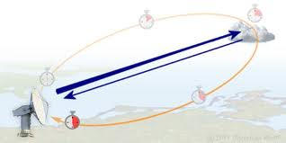
(Figure 1 - Principle of meteo radar )
To be able to detect all the precipitation sized droplets in the atmospheric volume around the radar, the antenna must perform sweeps or scans of this volume at different angles. Typical values of elevation angles are between 0.5° and 1° to scan the low levels and up to 30° or more for the upper levels. Usually, the radar antenna rotates at a speed of 2 to 4 rotations per minute but scanning velocity up to 6 rotations per minute are possible.
(Figure 2 - Scans)
Our weather radar has different scan strategies. The one mostly used makes two sweeps at 0.5° elevation angle followed by sweeps at 1°, 2°, 3°, 5°, 8°, 12°, 17°, 25° and 35° of elevation.
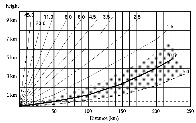
The fact that the radar sweeps need to be done with the antenna at a certain elevation leads also to the fact that the further away you are from the radar, the higher your radar beam will be in the atmosphere. Please refer to the figure 2 where, at a distance of 200km from the radar:
- the centre of the beam emitted at an angle of 0.5° will be at an altitude if 4km above the surface
- the lower border of that same beam will be at 1.5km above surface;
- and the upper border of the beam will be at almost 6km altitude.
If we take the same example (centre beam at 0.5° and distance from radar 200km) this also means that all cloud droplets below 1.5km or above +/- 6km will not be detected.
II. Radar products on the website
Once all these scans are done, we produce two different types of products for display on the website.
1. RADAR 245 Km (PPI or Plan Position Indicator)
A PPI-image is an image produced from a single sweep at a single elevation. The PPI-image posted on our website is a PPI at 0.5° elevation to be able to "look as far as possible" i.e. 245km. Obviously one should always be aware of the limitations of radar technology, i.e. :
- at a long distance from the radar site (245 km in our case) no cloud droplets below 1.5km or above +/- 6km will be detected;
- close to the RADAR site, only the low level droplets will be detected. For example with a 05.° radar beam elevation at a distance of 50km, only droplets between +/- 200m and 1km altitude will be detected.
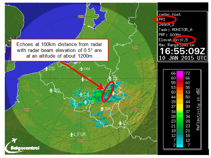
(Figure 3 - Example for PPI-image 245 Km)
2. RADAR 125 Km (Max image)
This image is based upon the scan of the complete volume of radar data (all angles of elevation), but is limited to a max distance of 125 km from the radar location. With ref to figure 2, this means that all echoes detected between earth's surface and +/- 20km altitude will be displayed.
The echoes that are displayed are calculated by taking the highest reflectivity value in the whole volume (between surface to 20 km altitude). When looking at the chart area of the MAX picture you do not have an indication on the vertical distribution of the echoes.
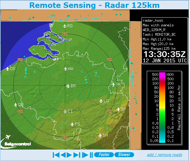
(Figure 4 - Example for MAX-image 125 Km)
To give an indication on the vertical distribution, we have added two projections add the top and right side of the chart. The E–W maximum projection is obtained by taking the maximum reflectivity along the corresponding N–S line. Likewise, the N–S maximum projection is obtained by taking the maximum reflectivity along E–W lines. So these two projections give an indication where the echoes are found in the vertical plane, but no indication on where the echoes are found in the horizontal plane.
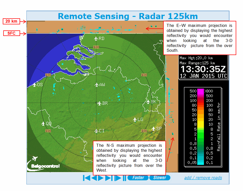
(Figure 5 - Example for MAX-image 125 Km)
3. MET Alliance Precipitation and Lightning Intensity Picture (PLIP)
Intro
The MET Alliance is a group of national aeronautical meteorological service providers that collaborated in the development of a Precipitation and Lightning Intensity Picture (PLIP) covering Europe Central. PLIP data represents near-real-time rain intensities combined with lightning discharge data.
DATA shown
The PLIP image contains the radar reflectivity measurements of precipitation scans with a time resolution of 5 minutes (EuRadCom) combined with lightning discharge data originating from the LINET lightning detection network
The precipitation intensity is indicated by a distinct colour coding varying form "marginal" (light blue) to "extreme" (dark blue/purple). The intensity legend is included at the bottom of each picture.
The lightning data in the PLIP is depicted with a filled purple diamond  showing the lightning strokes of the 5 minutes preceding the time indicated in the picture's legend. In other words lightning activity from 07:45 UTC till 07:50 UTC will be depicted in the 7:50 UTC image. The lightning data covers the complete geographical area shown, meaning that there are also possibly strokes depicted in areas where there is no radar coverage.
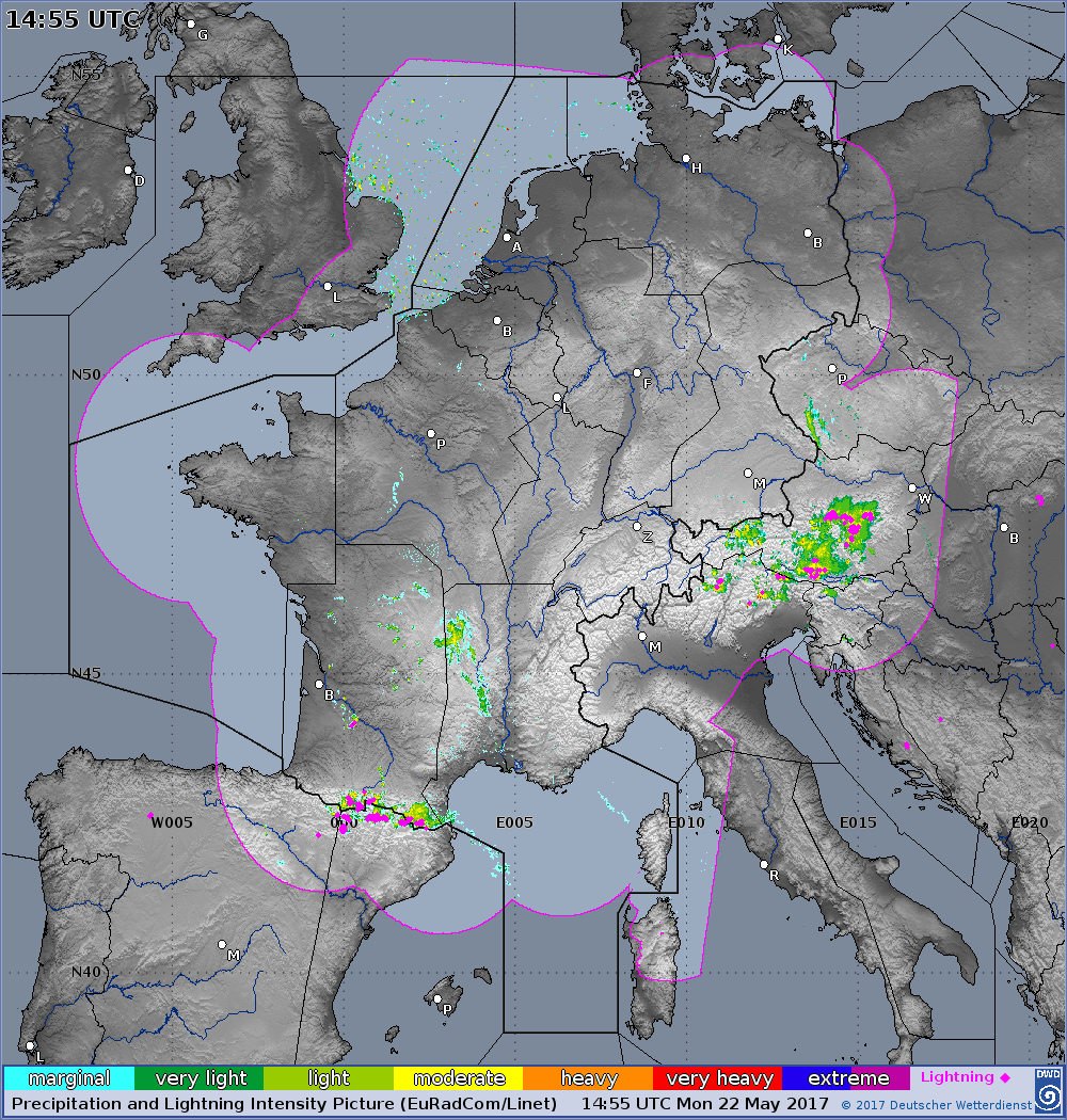
(Figure 5b - Precipitation and Lightning Intensity Picture)
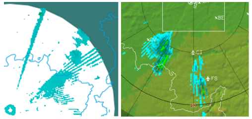
(Figure 6 - Example of second-trip echoes)
Second trip echoes are "false" echoes which appear on the radar images as parallel lines or rain zones of little intensity. They do not depict actual rainfall but are caused by the presence of other weather systems at great distances (usually large convective systems at 200 to 300km).
The radar emits pulses at a certain frequency and receives the reflected return of this pulse. The distance between the target (precipitation) and the radar is calculated from the difference in time between the moment of emission of the pulse and the reception of the reflected pulse. However, when the radar receives the reflected "first" pulse after the emission of a "second" pulse, calculation of the distance will be wrong. As a consequence, the precipitation will appear on the image at shorter distance to the radar compared to actual distance, because the radar "believes" that the reflected pulse it receives is a reflection of the "second" pulse rather than a reflection of the "first pulse".
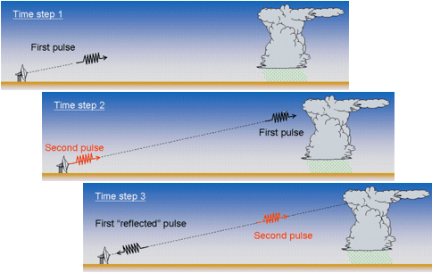
(Figure 7- Explanation of second-trip echoes)
2. Anomalous Propagation
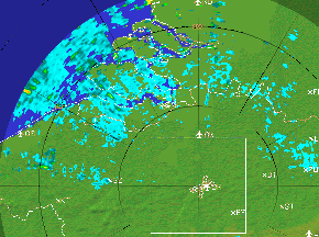
(Figure 8 - Example of anomalous propagation)
When the weather is "stable", often a temperature inversion is formed in the lower levels of the atmosphere. A temperature inversion is the phenomena where there is an increase in temperature with altitude instead of the normal decrease with altitude. This inversion can deflect or "bend" the radar pulses to the earth's surface, where they are reflected back to the radar dish. Consequently, the echoes visualised on the radar image are a reflection of the earth's surface and not reflections of rainfall.

(Figure 9 - Temperature inversion)
Satellite Imagery
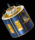 The Meteosat Second Generation (MSG) satellites are geostationary weather satellites developed by a joint venture of ESA ( European Space Agency) and EUMETSAT ( European Organisation for the exploitation of Meteorological satellites). Meteosat-8 is operational since mid-2004, transmitting new observations every 15 minutes in 12 spectral channels. The previous series of weather satellites 'only' transmitted observations every 30 minutes in 3 spectral channels (visible, infrared and water vapour)
Knowledge of meteorology and climate has evolved tremendously thanks to the availability of detailed satellite images. That is why satellite observations are an essential input for weather models and they are very important for weather predictions in the short and medium term.
It is also possible to observe cloud patterns through satellite images and to continuously follow up their evolution.
MSG - Infrared Satellite Image
An infrared satellite image is created by measuring the thermal radiation emitted by the earth's surface and the cloud tops. That is why an infrared image is actually a temperature chart of the underlying surface. In order to simplify the interpretation of the satellite image, the original black-and-white image was artificially coloured in. Low temperatures (high cloud tops for instance) are white or light blue zones. Higher temperatures are indicated by grey zones. By using a colour scale, it is easier to distinguish the earth's surface, the clouds and the water surfaces.
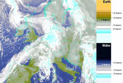
Thick clouds with high tops (cold) appear very white or light blue.
Thin low clouds with relative warm tops appear grey.
MSG - Visual Satellite Image
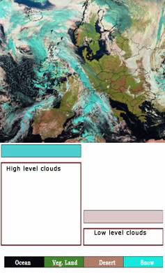 The visual image on the website is a composed image. The satellite image is a combination of 3 visual spectral channels, each of which was assigned a specific colour red, blue or green. This technique allows for marking the contrast between different cloud types through colours. This combination accentuates the contrast between water droplets and ice crystals.
These images are useful for distinguishing high clouds from low clouds, localising storm clouds (CB's) and observing snow fields.
MSG - Visible grey scale image
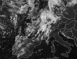 The grey scale image is a Higher Resolution Visible picture. The geographical coverage has been reduced in order not to degrade the quality when displaying the image.